The Sky Maps
(Disclaimer: India has a great astronomical tradition. We have tried to give the Indian names of the stars and constellations (like Nakshtras) for the purpose to remind the reader of this rich tradition. We would also talk about positions of planets (grahas) in different constellation which is for the purpose of where to look for those.
No member of this committee subscribes to astrology.)
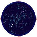
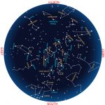
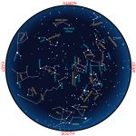
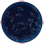
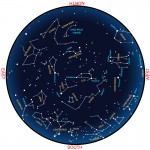
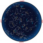
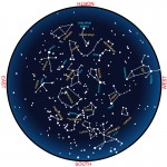
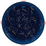
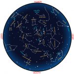
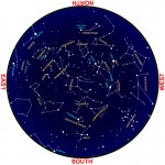
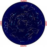
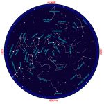
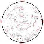
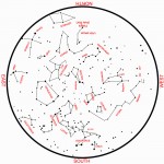
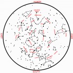
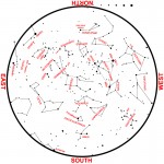
Given below are two sets of all sky star maps. These maps can be used anywhere in India at about 21:00 hrs on the 15th of the given month. The same map can be used at ~22:00 hrs. earlier and at ~20:00 hrs. later that month.
The star map given here are drawn for central station of India (Long 82.5, Lat. +23deg 11′), at 21:00 hours Indian Standard Time (IST). The maps shows slightly more sky than that will be visible from this station. That is the angular diameter of the horizon circle is 220 deg. instead of normal 180deg.
The maps are drawn using stereographic projection (see wiki link), that preserves the shape but distorts the size. In this projection system the objects closer to the periphery, in this case the constellations closer to horizon would look slightly bigger than those close to the zenith.
The stars are shown with dots in proportion to their brightness or magnitudes. That is brighter stars are marked with bigger dots.
Most constellations are shown by joining straight lines. At times some stars are joined with broken lines. These stars form what are called asterism which is a group of stars not part of standard list of 88 constellations recognized by the International Astronomical Union but popularized by amateur astronomers.
We have two sets of maps. The first set of maps are coloured maps and maps in Duo colour where the text is given red in colour. You may print these maps on a colour printer and when use with red touch light the text will nearly disappear and only the stars will be seen. You can get back the text using white or green light. You may, of course print these on a black and white printer. Click on the map to Enlarge, save and print.
We have also given some information stars and constellation associated with each month. And diary of astronomical events for a month. Please check the links below.
Coloured maps
-
- January
-
- February
-
- March
-
- April
-
- May
-
- June
-
- July
-
- August
-
- September
-
- October
-
- November
-
- December
Duo coloured maps
-
- May
-
- June
-
- July
-
- October
Notes on star gazing click on the month (click on the links):
January :: Februry :: March :: April :: May :: June ::
July :: August :: September :: October :: November :: December
This page is maintained by – Arvind Paranjpye
In case of doubts/questions/suggestions please email to paranjpye.arvind@gmail.com
Why should you not put indian/ sanskrit names for the celestial objects along with greek names.
Is ASI not proud of India’s ancient language n culture.
do the maps come under CC.(creative commons)?
may I use and upload these maps in my website?
Indian Astronomy does not have names of all stars and constellations. If you give only sanskrit names only a limited sanskrit knowing audience can understand it. So international nomenclature which are mostly borrowed from Greek and Egyptian astronomy should be used. Attempt to indianise everything will lead you to frog-in-the-well situation. So please use international nomenclature.
Thank you for putting up these maps. They are really helpful. But its important that ASI also use indian nomenclature for all the stars/constellations It’s is quite disappointing.